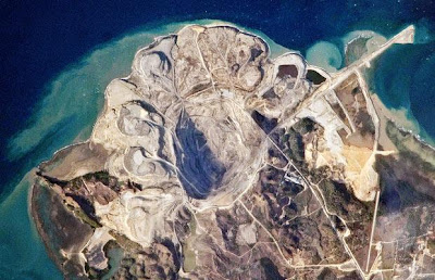
Uma visão do Observatório Earth mostrando a parte norte da Ilha Semirara, aproximadamente a 280 quiilômetros ao sul de Manila, nas Filipinas. A parte norte da ilha é dominada pelo campo de carvão Panian, o maior dos três que há na ilha. Vários reservatórios escuros de carvão são visíveis ao longo da escarpa sul, na fenda iluminada pelo Sol. Colunas de sedimentos das pilhas superqueimadas entram pelo Mar Sulu ao longo das linhas costeiras do leste e do norte da ilha.
A NASA Earth Observatory view of the northern end of Semirara Island, approximately 280 kilometres to the south of Manila in the Philippines. The northern part of the island is dominated by the Panian Coalfield, the largest of three coalfields on the island. Several dark coal seams are visible along the sunlit southern wall of the pit. Plumes of sediment from the overburden piles enter the Sulu Sea along the northern and eastern coastline of the island.
Nenhum comentário:
Postar um comentário